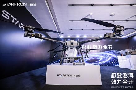
StarFront unveils the M150 agricultural drone with great impact. Through technological innovation, it aims to drive the future of agriculture.
OnDecember30,2025,theagriculturaltechnologyfieldwitnesseditsannualflagshipevent.The"StarFrontZhewang
Qianji Technology empowers classic ips with drones and helps the Shanghai International Light and Shadow Festival create the "Wusongkou Aerial Theater".
/PRZWT/AsamajoreventoftheBaoshansub-venueofthe2025ShanghaiInternationalLightandShadowFestival,onthee

The opening of the 2024 World drone Conference, the amazing "debut" of all new products of Puzhou Technology
/PRZWT/SHENZHEN,May29,2024-Withthedeepeningofanewroundoftechnologicalandindustrialrevolutions,thewor

China's wind power sector welcomes new blood: new orbital cruise detection drone vitality debuts - Press Release
/PRZWT/February23,2024BEIJING-AccordingtothelatestdatafromtheNationalEnergyAdministration,China'stot

A journey of hardcore discovery! A Dowcom Smart EVO Nano+ drone looks down on a volcano in Iceland
Guangzhou, August 25, 2022 -- Lava flowed from a fissure in the ground around the erupting Fagladar volcano near the town of Grindavik on Reykjjanes Peninsula, Iceland. Fagladar is near southern Iceland, not far from the famous Blue Lake hot springs and Iceland's international airport
The World drone Conference ends with a new player in the drone industry
Guangzhou, July 28, 2022 -- The 6th World UAV Conference 2022 with the theme of "Coming in the Future, Flying Dreams" was held at Qianhai Marriott Hotel in Shenzhen from July 23 to 24. Uav manufacturers and partners from all over the world will seek common development of the industry. There is no
Puzhou Technology is about to release a new drone, opening a new imagination of low-altitude infrastructure
Over the past few years, the size of China's UAV market has grown rapidly, according to Frost& Sullivan data shows that the scale of the national civil UAV market exceeded 40 billion yuan in 2018 and the national civil UAV market in 2021

For the first time, DJI has released the panorama of its drone mapping solution
Recently, DJI industry applications for the first time released the mapping solution panorama, showing the full series of aerial survey remote sensing solutions including visible light aerial survey applications, lidar applications, multi-spectral remote sensing applications. These solutions are complete